First Aerial Land Survey Completed
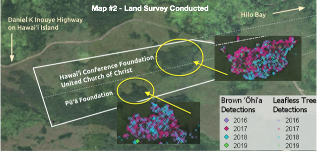
In April 2023 we received the first results from the aerial survey for Punahoa Heritage Forest. The survey uses modern mapping technology to help identify physical elements such as ground elevation, tree height, o’hia detection, and land cover. To get an initial benchmark, we were able to obtain maps using 2019 survey data.
Read More
Fundraising on track to $25,000!
Thanks to a generous gift of $2,000 from the State Council of Hawaiian Congregational Churches, the Punahoa Heritage Forest is about to reach 25% of their 2022 fundraising goal. A new supporter has also been secured to help raise awareness and interest in the Punahoa Heritage Forest initiative.
Read More
Special Benefit Event - Waimea Valley - Saturday, MAR 25, 2023
Join us at Waimea Valley for a special benefit event - Mālama ‘Ōhi‘a O Ka Nāhele - to raise support and awareness for Punahoa Heritage Forest. This family-friendly event features live music, food, hula, Hawaiian games, and vendors.
Read More
A Chant for Punahoa - “He Mele No Punahoa”
During a mele workshop led by Kekuhi Kealiʻikanakaole, a group of dedicated practitioners drew inspiration from Aunty Edith Kanakaʻ ole and honored her legacy of chant by developing this chant for the Punahoa Heritage Forest, a mele wahi pana.
Read More
First $22,000 received!
The Pūʻā Foundation gifted $20,000 at its board meeting today to help start the Punahoa Heritage Forest initiative. This creates a great start to kicking off the fund raising program which has an initial goal in 2022 of reaching $100,000.
Read More